Training and construction is still underway for the upcoming
nesting season. Rather than bore you the causal blog reader with the details of
proper power tool usage or how euthanize a lab rat, instead I’ll run down a
brief history of the town I’ll be working out of for the next four to six
months.
Astoria Oregon is a modest collection of quaint old
Victorian houses perched in rows along a steep terraced hillside. Most residents
have a view of the handsome green Astoria-Megler Bridge spanning the mighty
Columbia River, connecting Oregon to Washington. My bedroom window overlooks some
of downtown and Washington on the northern banks of the Columbia. When fog
infiltrates the river I can hear the deep baritone of ships blasting their fog
horns, sometimes at two in the morning.
Not only famous for its role in “The Goonies”, Astoria happens
to be the oldest settlement on the west coast. John Jacob Astor, a wealthy fur
trader from New York, saw great potential in the abundance of pinnipeds in the
North Pacific. In 1811 he established a settlement then referred to as Fort
Astoria, which served as the hub of the fur trade industry on the west coast
and led to the creation of the North American Fur Trade in the following years;
responsible for removing over 150,000 Northern Fur Seals from the Farallon
Islands and many more from various other rockeries in the region. Astor’s
success in the fur trade and in part through real-estate in New York made him
the wealthiest man in America when he died in 1848; he was worth at least 20
million. Not sure how much of his estate was left to the town that bears his
name, but I’m sure the Goonie tourists who must flock to this place bring
enough revenue to keep Astoria afloat.
Like most people I know little about the War of 1812, but
apparently during that time a British warship entered the Columbia River and
occupied Astoria in an effort to seize control of the lucrative fur trade.
Although the war was over in less than three years, the British remained in
Astoria, known by them as Fort George, from 1813 through 1818. I’m rather glad
the British decided to do this; Fort George is one of, if not the finest Brew
Pub in town. They even have a corn-hole court and a foosball table in the
tasting room.

As mentioned Astoria sits along the mighty Columbia River,
the largest river in the Pacific Northwest and the fourth largest river by
volume of discharge in the United States. The fingers and branches of its
massive watershed reach well into the northern Cascades of British Columbia.
The combination of strong tidal currents, high discharge rates, and powerful
North Pacific swells make the Columbia River bar the most hazardous crossing on
the west coast. Thousands of vessels and over 700 lives have been lost trying
to navigate the entrance to the Columbia. Vessel traffic in and out of Portland
just upstream and salmon fisherman in the summer make the Columbia a busy
waterway, and add to the rate of maritime accidents. We will be working on an
East Sand Island in the river itself, launching from the Washington side, and
although the currents and shifting mud flats will make the work challenging, luckily
we won’t have to brave the bar.
Also I made a mistake on the map of East Sand on my previous
post, the sliver to the right is the actual island we will be working on.

 With training now complete, most of the past week has been dominated
by the construction of a 600 ft long network of tunnels in the cormorant colony
on East Sand Island. Unlike the unassuming albatrosses that allowed us to walk straight
up to their nests on Tern Island, Double-crested Cormorants are especially
sensitive to human disturbance. We simply can’t just strut about the colony
during breeding season. If we did all the birds would flush and abandon their nests
regardless of their contents, leaving any eggs or chicks exposed to the
ravenous Glaucous-winged/Western Gulls that also breed on East Sand. The
tunnels will allow us to navigate the colony and access observation blinds without
causing disturbance. Special capture spurs outfitted with trap doors will also permit
us to temporarily remove birds from their nests to be outfitted with tracking
devices like satellite tags. The Google Earth image of the cormorant colony on
East Sand shows the old network of tunnels similar to what we are building this
year on a different part of the island. The black dots are Double-crested
Cormorants on nest bowls made of sticks and debris. The white coloration is
cormorant shit that I will coat everything, including me, by the end of the
season.
With training now complete, most of the past week has been dominated
by the construction of a 600 ft long network of tunnels in the cormorant colony
on East Sand Island. Unlike the unassuming albatrosses that allowed us to walk straight
up to their nests on Tern Island, Double-crested Cormorants are especially
sensitive to human disturbance. We simply can’t just strut about the colony
during breeding season. If we did all the birds would flush and abandon their nests
regardless of their contents, leaving any eggs or chicks exposed to the
ravenous Glaucous-winged/Western Gulls that also breed on East Sand. The
tunnels will allow us to navigate the colony and access observation blinds without
causing disturbance. Special capture spurs outfitted with trap doors will also permit
us to temporarily remove birds from their nests to be outfitted with tracking
devices like satellite tags. The Google Earth image of the cormorant colony on
East Sand shows the old network of tunnels similar to what we are building this
year on a different part of the island. The black dots are Double-crested
Cormorants on nest bowls made of sticks and debris. The white coloration is
cormorant shit that I will coat everything, including me, by the end of the
season.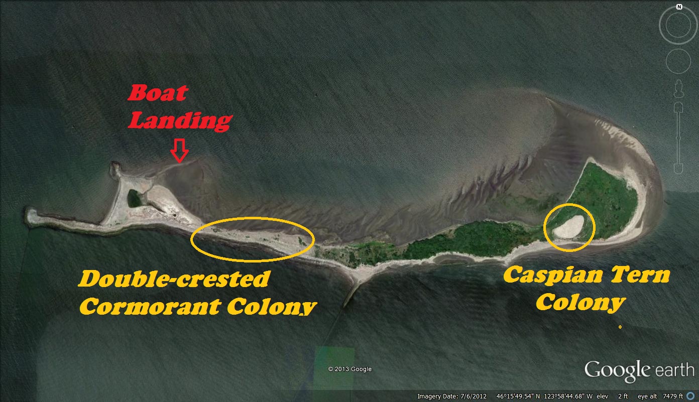 As you can imagine building over 600 feet of tunnels on a
cold sandy island at the mouth the Columbia is not the easiest of tasks, and requires
a fare bit of labor. We first had to construct the vertebrae and framework of
the tunnels back in Astoria, and move all materials by boat across tidal flats
and onto site. An ATV helped with moving some of the heavier gear like
generators and air compressors. A-frames roughly four feet high make up the
backbone of the tunnels spaced about 15ft apart, held together by 2x4’s running
along the apex. Silt fencing draped over the skeleton provides the skin, anchored
into the sand by burying the edges. The fencing is pulled tight and tacked into
place with slats and staples. Access points in and out the tunnels are caped
with wooden blinds and the terminal ends contain capture spurs that branch like
arteries into the colony. Double-crested Cormorants apparently like to nest in
old tires, which are strategically placed near the capture spurs to encourage
birds to nest near the trap doors. We are nearly finished with laying out the
framework and fencing, and should have the entire network ready for use by the
end of the week. There is also a Caspian Tern colony on the opposing side of
the island that will require some set up as well before the birds begin to
arrive sometime next month.
As you can imagine building over 600 feet of tunnels on a
cold sandy island at the mouth the Columbia is not the easiest of tasks, and requires
a fare bit of labor. We first had to construct the vertebrae and framework of
the tunnels back in Astoria, and move all materials by boat across tidal flats
and onto site. An ATV helped with moving some of the heavier gear like
generators and air compressors. A-frames roughly four feet high make up the
backbone of the tunnels spaced about 15ft apart, held together by 2x4’s running
along the apex. Silt fencing draped over the skeleton provides the skin, anchored
into the sand by burying the edges. The fencing is pulled tight and tacked into
place with slats and staples. Access points in and out the tunnels are caped
with wooden blinds and the terminal ends contain capture spurs that branch like
arteries into the colony. Double-crested Cormorants apparently like to nest in
old tires, which are strategically placed near the capture spurs to encourage
birds to nest near the trap doors. We are nearly finished with laying out the
framework and fencing, and should have the entire network ready for use by the
end of the week. There is also a Caspian Tern colony on the opposing side of
the island that will require some set up as well before the birds begin to
arrive sometime next month. 
